WEGA in the North West United States
May 29th to June 11th 2016

Day 1 - Sunday 29th May 2016
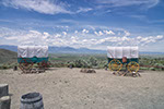
After the normal hold-ups usual at the start of an excursion - deciding who was going in which people carrier (or van - one of the vehicles turned out to be a Ford Transit!), packing the bags, arranging the running expenses etc. We set off for our first stop, the Walmart supermarket in Chehalis to get stuff for lunch.
Doug sorting out the finances at the supermarket in Chehalis.
The map on the left shows our route. You can find all the photos I took on this day HERE.
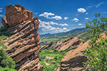
After exploring the riches of Walmart we continued south along Interstate 5 (I-5) until we got to our junction and headed east into the Cascades.
Cascade Volcanic Arc
The Cascades Volcanic Arc runs S-N from Lassen peak in California, to Mt Baker in northern Washington and continues into British Columbia. This arc represents the last phase of the convergence of the Pacific against the North America plate. Through the Mesozoic, subduction extended along the entire length of the North American continent. In the Tertiary, part of the mid Pacific ridge collided with the subduction zone about the position of Los Angeles, with the convergence then being replaced by strike slip movement
along the San Andreas fault. For the rest of the Tertiary, the San Andreas has extended northwards as further portions of the Pacific mid ocean ridge collided with the trench. The remnant Juan de Fuca plate that has not yet been subducted, extends north from the Mendocino transform fault in northern California.
The arc actually consists of two distinct parallel volcanic rock sequences as shown below. There is an older volcanic arc of the Western Cascades, which is dominantly composed of andesite, basaltic andesite, dacite and associated pyroclastic material of intermediate composition. The younger volcanic arc rocks of the High Cascades are also dominantly intermediate composition andesites and basaltic andesites, but there are also multiple isolated centres of silicic dacite and rhyolite.
Geological Background continued HERE.
The words above in blue are taken from the handout provided by Doug Robinson - see details HERE.
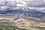
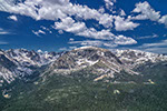
As we drove into the Cascades we noticed that the valleys were no longer mountain valleys with characteristic V shapes and interlocking spurs, but had been infilled. And we crossed a very long and new bridge over Hoffstadt Creek - we were seeing the signs of the Mount St Helens eruption of 18th May, 1980.
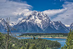
We passed all these manifestations, finally stopping at the Johnston Ridge Observatory. Dave Johnston was a USGS geologist who died in the eruption. Fifty seven people died when the mountain blew up - that number would have been much higher if he, and fellow workers, had not persuaded the authorities to close the area to the public, despite pressure to open it.

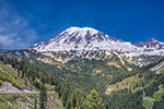
Mount St Helens from the Johnston Ridge Observatory. All the foreground, and much of the mountain, consists of volcanic ash blown out of the mountain on the 18th May, 1980. The mountain lost 1,308 feet in height
The eruption actually happened because of what, at first glance, was fairly innocuous. The mountain was bulging as magma rose into the mountain. The mountain slope became unstable so part of the bulge slipped down the mountain. This removal of material led to a reduction of pressure in the magma chamber, gas came out of the magma instantaneously, everywhere. The magma expanded into a very hot foam. (Think of opening a well shaken Coca Cola bottle). The foam went upwards and outwards travelling at up to 650 miles per hour. And with temperatures possibly up to 700°C one should avoid such situations!

A new lava dome is developing in the crater. Nowadays a very close eye is kept on the volcano.

View north from the Observatory. A close look will show a myriad of fallen tree trunks, all lying in the same direction. They were knocked down by the blast from the eruption

Inside the Observatory. This tree was growing 14 km from the volcano. The lateral blast reached it one minute after the eruption and snapped the trunk. This is a graphic illustration of the power of the blast.
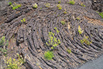
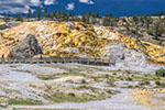
After our visit to the Observatory we drove back down the road to the Loowit Lookout to better see the vast quantities of ash filling the valley. There was a volunteer at the lookout with a telescope who was pointing out elk in the valley.

View from Loowit Overlook. The valley has been filled with ash. Note the felled tree trunks. All the growing trees are young
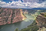
Farther down the valley we went for a walk through the woods to the river to look at the thickness of the volcanic ash.

Walking through the woods to the river.

View of the volcanic ash from across the river. The maps are ambiguous whether this is Hoffstadt Creek or the North Fork of the Toutle River.
If you have Google Earth, (you can get it HERE) download THIS file and store it some place on your computer. Then open Google Earth. Click File then Open and navigate to the stored file and click on it. This will give you our route for the day and my photographs, where I took them, superimposed on the route. All the days photos can be seen HERE.
WEGA in the North West United States